
 Key facts
Located in subregion/area: Montagne & Val de Reims / Massif de Saint-Thierry
Vineyards and grape varieties: 23.5 hectares (58.1 acres), of which 44% Pinot Meunier, 41% Pinot Noir, and 14% Chardonnay.
Classification: “Autre cru” (84%)
Maps

The map is linked from Wikimedia Commons, and the geographical information originates from OpenStreetMap. The dotted white area corresponds to the vineyards, light yellow is other open terrain, orange is built-up areas, and green indicates forest.
Google Maps view with the villages in the Massif de Saint-Thierry shown.
Clicking on a village opens a field to the left with a link to the village profile.
Neighbouring villages
On the right bank of Vesle, i.e., the same side as Montigny-sur-Vesle
Eastsoutheast: Prouilly
North: Pévy
On the left bank of Vesle, i.e., the opposite side
Southsoutheast: Jonchery-sur-Vesle (part of the Vesle et Ardre area)
South: Vandeuil (part of the Vesle et Ardre area)
Comment : several of the communes on the map (from northeast via northwest to southwest) are not part of the Champagne appellation and therefore don’t have any village profiles.

The town hall (mairie) of Montigny-sur-Vesle. Picture linked from Wikimedia Commons (photo G.Garitan, 2013).
The village
Montigny-sur-Vesle is located in the northwestern part of the Champagne region, a short distance northwest of Reims, on the right bank of the Vesle river.
The Montigny-sur-Vesle commune covers 946 hectares and has 521 inhabitants (as of 2016), referred to as Ignymontois and Ignymontoises.

The Virgin Grotto, la Grotte de la Vierge, which is a local sight just outside the village. The inscription reads “Immaculare virgine deiparæ. Anno 1865” Picture linked from Wikimedia Commons (photo G.Garitan, 2013).
Vineyards
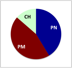
The vineyards in Montigny-sur-Vesle are located to the east and southeast of the village, and consist mostly of mild southwest- to west-facing slopes. Pinot Meunier and Pinot Noir dominate in the vineyards, in about equal proportions.
The current vineyard surface in the Montigny-sur-Vesle commune is 23.5 hectares (58.1 acres). There are 10.4 ha Pinot Meunier (44.3%), 9.7 ha Pinot Noir (41.3%), and 3.4 ha Chardonnay (14.5%). Current information from CIVC as of 2019, refers to the situation a few years earlier. In 1997, the vineyard surface was 20 ha. There are 7 vineyard owners (exploitants) in the commune.
Proposed expansion of the Champagne wine region
Currently, Montigny-sur-Vesle is the last village located within the Champagne appellation of the villages located on the Vesle river, as seen downstream from Reims, i.e., in the westnorthwestern direction. In the proposed expansion of the Champagne wine region/appellation with 40 new communes, several of Montigny-sur-Vesle’s neighbours are to be included in the appellation. On the right bank of Vesle this applies to Bouvancourt, Ventelay, Romain, Courlandon, and Baslieux-les-Fismes. This means that all communes between Vesle and the departmental border, from Châlons-sur-Vesle and downstream, will be part of the appellation. On the left bank of Vesle, Breuil(-sur-Vesle) and Fismes will be added, and are likely to be counted as part of the Vesle et Ardre area. Five of these seven villages are visible on the map above.

Orchards in Montigny-sur-Vesle with the church in the background. Picture linked from Wikimedia Commons (photo G.Garitan, 2013).
Champagne producers
Champagne growers
Producer status is indicated where known: RM = récoltant-manipulant, or grower-producers. RC = récoltant-coopérateur, growers that are cooperative members but sell Champagnes under their own name.
- Chevalier de Vreese (RC). Below a presentation video showing work in the vineyard:
- Fleury-Blondy (RC, Facebook page)
- F. Jacotin (RC), also called Les Chapitres des Clos, which is also the company name.
Comment: The list may be incomplete.
Links
- Wikipedia about this village in English, in French.
- Website of the Montigny-sur-Vesle commune.
- UMC’s village profile of Montigny-sur-Vesle.
- The Swedish version of this post.
© Tomas Eriksson 2015-2019, last update 2019-04-13
